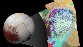


Pluto is a medley of geological textures. In order to gauge the numerous processes that have operated on Pluto, NASA has created a geological map of the dwarf planet’s rugged terrain.
A compilation of 12 images were used to create this map, which were gathered during New Horizons’ fleeting but fruitful passing of Pluto last year on July 14.
The images were taken by the spacecraft's Long Range Reconnaissance Imager (LORRI), 77,300 kilometers (48,000 miles) away from the icy surface. To give you a sense of scale, one pixel accounts for around 390 meters (1,280 feet).
In the center of the image, you can see Sputnik Planum (in pale blue-green), the icy plain surrounded by a hotchpotch of geological textures and morphologies. The black lines that web the icy plain depict the boundaries of cellular regions in the nitrogen ice.
Other interesting features include the yellow blobs on the left, which represent large impact craters, and the swath of red in the bottom-left corner that illustrates a potentially cryovolcanic mound known as Wright Mons.
As NASA explains, the information can also be used to work out when these geological processes occurred relative to each other, giving some sense of history to this far-out loner.
For a close-up view of the map, click here.

Image credit: NASA/JHUAPL/SwRI