


Glaciers are dynamic, flowing rivers of ice. When they meet the sea, the water can get underneath the lip and increase the rate at which they melt, which is what is happening to Pine Island Glacier in Antarctica. The speed at which the ice flows into the sea is also influenced by the land on which it sits, and now researchers have created the most detailed map yet of the rock beneath this Antarctic glacier.
What they found was that the terrain under the ice is far more varied than previously documented, which likely has a significant impact on the speed at which the massive chunk of ice is moving.
Pine Island Glacier is part of the West Antarctic Ice Sheet. This massive stream of ice is melting rapidly – it cuurently accounts for around 25 percent of all ice loss in Antarctica and around 10 percent of all ice loss globally. By 2007, it was found that the glacier was diminishing, releasing more water into the oceans than is replaced by snow, and it is expected to slide entirely into the surrounding waters within the next century.

The mass of ice has been of interest to scientists for a while, who have tried to map its underbelly using planes and satellites as they travel over it. But now researchers have managed to create the most detailed image of what is really under that 2 kilometers (1.2 miles) of ice, revealing an incredible landscape covered in mountain peaks, valleys, and cliffs. This new information will now change the models for how this glacier flows, as well as alter what is known about the predicted rate of ice loss in the future.
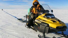
Published in the journal Nature Communications, the team used snowmobiles equipped with radar sensors to survey the Pine Island Glacier, taking readings every few hundred meters across a 1,500-square-kilometer (580-square-mile) area of ice. They now think that these immense geological features under the ice will slow the flow of the glacier into the sea, while regions that are flatter may aid it.
“These maps have revealed new features under Pine Island Glacier that we never thought were there,” explains Professor David Vaughan, from the British Antarctic Survey, in a statement. “The bed turns out to be much rougher than we thought. There are mountains and deep scour marks which are clearly going to be influencing the flow and behavior of the ice. In order to really understand how the glacier is going to respond to future change, we need to understand its interaction with the bed and these high resolution maps let us begin to do this."


