

Africa is far bigger than you may think. If you look at a map or globe, the continent looks pretty large compared to other land masses, but this representation is not accurate. In reality, Africa is enormous. In fact, you could fit China, India, all the states in the contiguous US, and most of Europe into the space it actually takes up. So why is Africa so small (comparatively) when displayed on a map?
The rest of this article is behind a paywall. Please sign in or subscribe to access the full content.“The map is not the territory,” Alfred Korzybski once stated when explaining how people tend to confuse models of reality for reality itself, and this expression is particularly apt for modern maps. As with any attempt to represent complexity in simplified models, there are trade-offs.
The problem is simple. How do you turn a sphere into a flat projection without distorting the outcome? Today, we have various ways of achieving this, but for a long time, the features of our world maps were influenced by what is called the Mercator projection. This was a tool used for nautical navigation that has had a lasting influence on most of our maps.
Gerardus Mercator was a 16th-century cartographer who created the flattened projections, complete with latitude and longitude, that we are familiar with today. Mercator’s approach used a cylindrical projection that was valuable for sea travel, as the lines he included that make up the map’s grid were a constant course (loxodrome).
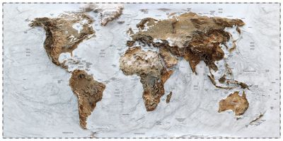
However, because the features of the projection were intended for navigation, rather than for accurate geography, the landmasses nearer the poles are distorted and stretched. So, while Africa appears smaller than it actually is, other places have been inflated. Greenland is actually significantly smaller than it appears to be on the map and so too are Europe and North America.
Russia would appear to take up around 25 percent of the planet’s surface, but in reality, it only covers about 5 percent. Want to see the world shrink to its true scale? Climate data scientist Neil Kaye created a handy gif that reduces the inflated continents to their actual proportions.
#maps #GIS #projectionmapping #mapping pic.twitter.com/clpCiluS1z— Neil Kaye (@neilrkaye)
Despite these significant distortions, Mercator’s projection is still commonly used today. This means that many people are not aware of how our planet actually looks. Moreover, the distortion also impacts specific countries and can make them appear larger than they really are.
Such distortions can have an impact on how we understand ourselves and our place on the planet, so in an increasingly connected world, we should have a more accurate understanding of how everything fits together.
All “explainer” articles are confirmed by fact checkers to be correct at time of publishing. Text, images, and links may be edited, removed, or added to at a later date to keep information current.