

Declassified imagery from Cold War-era spy satellites has revealed hundreds of long-lost Roman forts across Syria and Iraq.
Ancient forts were first documented in the Near East in the 1920s when Jesuit priest Father Antoine Poidebard undertook one of the world’s first aerial archaeological surveys. His studies counted a line of 116 forts, suggesting that they were used to protect the eastern frontier of the Roman Empire from marauding invasions from the Arab world and Persia.
In this new survey, researchers at Dartmouth College took another look at the area by studying 20th-century satellite imagery of the Near East that became declassified after the Cold War.
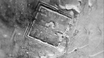
By noticing imprints within the landscape, they identified a total of 396 new Roman-era forts in the Syrian steppe.
“Archaeological features that we classified as probable forts are easily distinguished from modern buildings due to the distinctive shadows cast by the latter, compared with the lower, eroded walls that are visible at archaeological sites. The most common form that we interpret as a probable fort is a classic square shape, typically 50-80m [164-262 feet] per side,” the study authors write.
The team was only able to pinpoint 38 of Father Poidebard’s original forts, suggesting many of these archaeological remains have vanished over the past century in the wake of intense agriculture and urbanization.

Interestingly, the hundreds of newly discovered forts were widely spread from east-to-west, indicating they were not necessarily part of an enforced north-south border to protect from eastern invaders.
Instead, the researchers speculate that the complex of fortifications was there to help the movement of troops or trade goods across the region, protecting commercial caravans traveling between the eastern provinces to non-Roman territory.
If this interpretation is correct, it could have some big implications for how we view this part of the Roman world. Firstly, it indicates the Empire's eastern extent didn’t have strict borders. Secondly, it suggests that this region was more about trade and commerce than warfare.

"Since the 1930s, historians and archaeologists have debated the strategic or political purpose of this system of fortifications, but few scholars have questioned Poidebard’s basic observation that there was a line of forts defining the eastern Roman frontier,” Professor Jesse Casana, lead study author and archaeologist at Dartmouth College, said in a statement seen by IFLScience.
As more imagery from the 20th century becomes declassified, more new archaeological discoveries like this will be made possible. For instance, in 1997, the US government declassified thousands of photos taken by U-2 spy planes that flew over the world during the 1950s and 1960s. These images are said to have a better resolution than Google Earth and have the potential to reveal all kinds of archaeological relics from the past.
“Careful analysis of these powerful data holds enormous potential for future discoveries in the Near East and beyond,” added Casana.
The study is published in the journal Antiquity.