

A new satellite has returned a stunningly detailed image of the ground on Earth, showcasing what we can expect from online map services in the future.
The image was taken by DigitalGlobe’s WorldView-4 satellite, which launched on November 11 on an Atlas V rocket. The company uses its fleet of satellites to provide images to customers such as Google Maps.
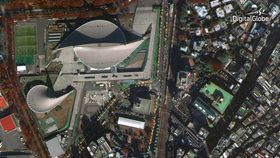
Taken on November 26, the image shows the Yoyogi National Gymnasium in Shibuya, Tokyo, a site used in the 1964 Olympics, and the surrounding buildings and infrastructure. The image really is quite remarkable; you can easily make out cars, and even the shadows of people playing soccer on a nearby pitch. A larger version is available here.
The image was snapped from an altitude of 617 kilometers (383 miles), according to Mashable. The camera on board, called the SpaceView 110, has a resolution of 31 centimeters (12 inches) per pixel. WorldView-4, as its name suggests, is the fourth satellite in the WorldView series, and was built by Lockheed Martin.
Impressively, the satellite can see not just optical light, but near-infrared too. This could help to find wildfire hotspots through smoke, for example, or see changes in vegetation on the ground. In one day, the satellite can snap 680,000 square kilometers (260,000 square miles) – about half the area of the US – by using gyroscopes on board to orientate itself.
In a statement, DigitalGlobe said WorldView-4 would double their capacity “to globally collect the world’s highest-resolution commercial satellite imagery”. For us, well, navigating the globe could get a whole lot easier.

An up close view of a soccer pitch in the image. DigitalGlobe