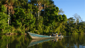


The towering trees of the Peruvian forest – many of which have lived through more than five human generations – are no match for the razored teeth of chainsaws in the hands of illegal fellers. In just five years, almost 6 percent of the Madre de Dios region has been cleared of trees.
The rest of this article is behind a paywall. Please sign in or subscribe to access the full content.At first, this figure may not sound too shocking, but expand such destruction out to a century and little is left if the pace of deforestation continues. The time-lapse was mapped by graduate research assistant Andrea Nicolau of the University of Alabama in conjunction with Servir, a joint venture between NASA and the US Agency for International Development that provides satellite data to help improve environmental decision-making.
Madre de Dios – which means "Mother of the God" – is a biodiversity hotspot in southeastern Peru around 3,500 square kilometers (1,350 square miles) large and with plenty of endemic species found in no other region of the world. Using Landsat 7 and 8 observations from 2013 to 2018, Nicolau found that roughly 206 square kilometers (79 square miles) of forest were cleared during those years. She used spectral mixture analysis to identify specific types of land cover, providing her with the ability to distinguish between illegal logging and land clearing for agriculture, which tend to occur in square patterns.

The largest losses were in buffer zones around protected areas, including the Tambopata National Reserve and lands that belong to the Kotsimba Native Community. The team suspects the construction of the Interoceanic Highway through the region may have facilitated tree loss, particularly in the last year that saw the greatest depletion, due to easier access to the forest.
These buffer zones are created to restrict resource use, but are not on par with laws in nearby protected areas. It is, in a sense, a transition zone to enhance the protection of conservation areas. However, Nicolau found that nearly half of the tree loss took place outside of legal mining areas.
Most of the logging in the forests of Peru are selective, meaning those of the highest value are targeted. It's also typically in regions with logging roads, many of which are located in Ucayali, Madre de Dios, and Loreto.