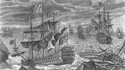


On October 21, 1707, a fleet of 21 ships led by Sir Cloudesley Shovell were returning to Britain from the Mediterranean, when they hit stormy weather.
Unable to simply check the sat nav, given their location in time, the crew was only vaguely certain of their location in space and stopped to confer between themselves. Determining an accurate latitude while at sea was a relatively simple case of measuring the angle between the North Star and the horizon, or the position of the Sun during the day. But longitude was a whole lot more difficult.
"One consequence of being unable to measure longitude directly was that seamen chose quite conservative routes. Heading on a direct course carried the real danger that if they missed their destination they might be uncertain which way to sail," the UK's Royal Museums Greenwich explains. "Instead, the usual practice was to aim well to the east or west. Once the ship reached the latitude of their destination, they would ‘run down the latitude’ on a westerly or easterly heading, confident that landfall lay ahead."
Early sailors, until the "longitude problem" was solved, relied on "dead reckoning" to find their longitude. This involved keeping careful notes of the directions traveled and the time that has elapsed since you were last at a known location, while also taking into account factors like wind speed. It wasn't an accurate way to travel and led to a hell of a lot of unexpected landfalls and a lot of ships being shipwrecked, as Sir Cloudesley Shovell was about to demonstrate before we rudely interrupted ourselves.
Between the crew, they determined that they were somewhere near the French island of Ushant off the coast of Brittany in France. But they were actually nowhere near where they thought, and the following night, to their surprise, the flagship Association smashed into rocks off the coast of the Isles of Scilly just south of mainland Britain, shortly followed by four of the other ships of the fleet. Over 2,000 members of the crew were killed, with just 25 survivors.
This ended up being the straw that broke the camel's back, and the British government decided the longitude problem must be solved. In 1714, it passed the Longitude Act, which offered £20,000 as a reward to anybody who could come up with a method of accurately determining longitude.
To be clear, there was already a known way of determining longitude, in theory at least. Each 15 degrees of longitude is the equivalent to a time difference of around an hour. So in order to calculate your longitude, all you need to do is determine the local time of your ship through use of the stars or the Sun, and then compare that time with the local time at home or another known location. The problem was that there was no way of accurately taking the time from home with you as you sailed.
"You have the fact that the pendulum clock will not work on board a rocking ship, it will just stop," Emily Akkermans at the Royal Observatory Greenwich, explained to the IFLScience Big Questions podcast.
"Another problem is that clocks inherently have a lot of friction, all the materials moving alongside each other, so they need oil to reduce the friction, but the oils of the day were all natural and they were bad quality for what they were doing, so they would turn acidic, dirt would collect in the oil, and the clock would cease to run accurately quite quickly," she said.
"So it would need to be stripped down, cleaned, put together, re-oiled, set going again, which is of no use to you if you're at sea and you're meant to have your clock tracking your time for you."
As well as this, fluctuations in temperature would wreak havoc on the pendulum, making any time you can get from it wildly inaccurate for your purposes (those being not smashing yourself into big rocks or finding distant lands, depending on your levels of ambition).
The man who would solve this problem was John Harrison, a carpenter who had taught himself to make clocks and who was working on a system that didn't need oil to lubricate them.
"He creates this wonderful system called the gridiron system," Akkermans explained. "So [under usual circumstances] if your pendulum rod expands, lengthens, time slows down. If it shortens, time speeds up."
"He used steel and brass rods put together in such a way that when the temperature rises and the metals expand, they do so in such a way that the length of the pendulum does not vary. The metals move, but the length remains the same. Again, that will compensate for any variations in temperature, which is a huge effect on timekeeping accuracy."
Harrison was convinced that he could produce a clock that would function at sea and which then could be used to solve the navigation problem and the associated "looks like we're drowning again" problem faced by sailors. After securing a little seed money, he was able to produce four portable clocks, the last of which – H4 – was able to accurately keep time on sea voyages.
However, by 1765 when the clock was trialed and shown to work, several other methods had been developed to solve the longitude problem, including the lunar distance method and one using the satellites of Jupiter.
Though the British government ended up recommending the clock method, with other manufacturers learning to make their own timekeeping pieces, Harrison wasn't compensated with the full £20,000. No matter what longitude you are at, the British Empire could be relied on to be jerks.