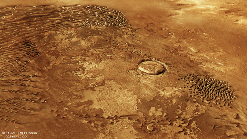
The ‘flyover’ comes courtesy of Mars Express which was launched by the European Space Agency on 2 June 2003 and arrived at Mars six and a half months later. The spacecraft has orbited the Red Planet nearly 12,500 times since its arrival and has beamed back data and images collected by the scientific instruments aboard.
This data was collated to create a nearly global digital topographic model of Mars’ surface, making the viewing of the ‘flyover’ a three dimensional experience. The images were taken by the High Resolution Stereo Camera (HRSC) run by the DLR German Aerospace Center; the flyover explores the grabens, valleys, canyons, mountains and lava flows in unprecedented detail. These 3D images aid researchers in understanding the climate and development of Mars.
The HRSC was pointed towards Earth while journeying to Mars, so it could provide evidence it had survived its launch from Baikonur Cosmodrome. The camera took an image of Earth and the Moon 3 July 2003 from nearly 8 million kilometres away; this was the first picture of planetary objects obtained by the Mars Express’s HRSC. The second image was taken when the probe was 5.5 million kilometres from Mars: the features were visible as light and dark areas and the ice around the South Pole appeared very bright and white.
When Mars Express finally reached its destination on 25 December 2003 the image it sent back was almost plain white. Though scientists at first worried the camera was not working, it turned out that the infrared channel, which is one of the nine channels on the camera, was still showing some weak contours of the Martian surface. The scientists realised the sensitivity of the camera close to Mars was far greater than expected and so the image had been overexposed. On 10 January 2004, with the correct exposure time, the first successful image was acquired from an altitude of 277 kilometres. The image showed part of the southern highlands near Isidis Planitia.
The video was constructed from camera images and put together piece by piece to create a global map of Mars. Mars’ surface is 145 million square kilometres and 97 million were already covered at very high resolution, where one pixel is equivalent to less than 20 metres on the surface. Now, almost the whole Martian surface has been imaged at a resolution of better than 100 metres. Some images were rendered unusable by clouds, haze or Martian whirlwinds, but what gaps in the record they could have created were filled by images from following flybys. The information will be combined with data sets from other missions like the Mars Global Surveyor or data from other instruments on the Mars Express spacecraft.
The HRSC has nine light-sensitive detectors that sweep the planet’s surface from nine different observation angles. The data is then processed into three-dimensional images by the DLR planetary researchers. The images have been used to determine that volcanism was still occurring on Mars until relatively recently: some of the shield volcanoes in the Tharsis region were still active a few million years ago.
The images have also provided further evidence that water once flowed on Mars’ surface, including the identification of outflow valleys three to four billion years old. There is further evidence that Mars’ ancient climate was far different from how it is today, with structures seen near the equator that would have been caused by glaciation.
The video was released by as part of the ten years of Mars Express celebrations in June 2013. Mars Express was originally due to end after one Mars year, but is now due to continue orbiting Mars until the end of 2014. The music in the video was created by Stephan Elgner of DLR's Mars Express planetary cartography team.