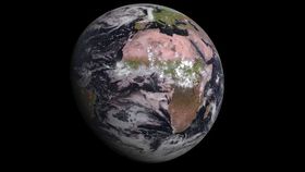


In this latest image from the European Space Agency (ESA), captured by its newest weather monitoring satellite MSG-4, Earth looks especially crisp and detailed.
Launched in July aboard an Arianne 5 rocket, this satellite is the fourth and final satellite in the Meteosat Second Generation (MSG) satellite series, a joint project from the ESA and European Organization for the Exploitation of Meteorological Satellites (EUMETSAT).
The satellite has an onboard camera called the Spinning Enhanced Visible and Infrared Imager (SEVIRI), which captured Africa, the western part of Europe and the eastern tip of South America. The quality of the image shows the diversity of Africa's landscapes with the subtropical desert of the Sahara at its north and vast rainforests covering much of its south.
Intended to replace an older MSG satellite, receiving this image means that the new satellite is functioning correctly, and it will eventually be renamed MSG-11.
Weather satellites are used to provide vital data and imagery of the Earth to forecast high-impact weather. Because these satellites are geostationary, they can take many snapshots of the same area to create a timelapse animation of the climate and weather.
Check out the image in greater detail below:
 EUMETSAT
[H/T: The Verge]