

One day in early February, Ecuador’s tallest waterfall disappeared.
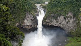
The rest of this article is behind a paywall. Please sign in or subscribe to access the full content.Until not too long ago, the Cayambe Coca National Park in the Ecuadorian Amazon was home to San Rafael Waterfall, a 150-meter (492-foot) high waterfall surrounded by lush vegetation and a stunning amount of biodiversity. But by February 2, 2020, the Ministry of Tourism Ecuador announced the gushing cascade of water had been reduced to a lightly trickling stream.
“Unfortunately, Cascada San Rafael is now part of history and will not return,” said a MAE spokesperson, according to CuencaHighLife, a local English-language news source.
The abrupt change was documented in photographs by the Ministry of Environment Ecuador (MAE) and NASA images taken by the Landsat 8 satellite.

MAE says the sinkhole was formed by landslides that occurred on February 2 around the Coca River. They have closed the surrounding area to tourists and continue to monitor the river for further landslides, as well as any potential risk to the park’s biodiversity. According to Mongabay, the landslides helped to create a sinkhole just a few meters before the waterfall, causing the water to flow in three separate sections down a less steep slope.
The precise cause of the landslides, however, remains a point of controversy.
The San Rafael Waterfall lays in a seismically active area that’s home to the Cayambe volcano and Reventador volcano, so a naturally occurring landslide is not all too surprising given the area’s geology.
On the other hand, some have suggested the landslides were actually the result of the recent construction of Coca Codo Sinclair Dam, one of Ecuador’s largest hydroelectric plants found upstream. The theory goes that the dam requires river water to be filtered so it doesn’t damage the equipment. The lack of sediment causes the water flow to become more erosive to the bed and banks of the river below the dam, making it more prone to collapse.
“A waterfall that has been there for thousands of years does not collapse, coincidentally, a few years after opening a hydroelectric project. These are processes that are in scientific papers and there is sufficient evidence that a dam can cause effects of this type on a river,” Emilio Cobo, coordinator of the South America Water Program at the International Union for the Conservation of Nature (IUCN), told Mongabay.