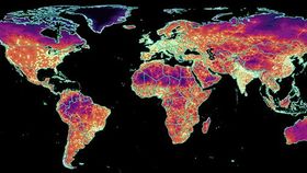


The Big Data Institute at the University of Oxford has published a map revealing how long it will take you to travel to the nearest urban area from anywhere in the world. The end result is a psychedelic masterpiece.
But it doesn’t just look stunning. It serves a very serious purpose. As the researchers point out, cities serve as a hub for all sorts of institutions and services, including education, healthcare, and banking. They hope the project will help inform future endeavors to improve transportation links and accessibility to urban centers without endangering the surrounding environment and local wildlife.
According to a statement released by the Big Data Institute, the map is “the most detailed assessment” of accessibility to date. It was published in the journal Nature earlier this week.
The last time accessibility to urban areas was looked at on a similar scale was in 2000. Since then, there's been a great deal of expansion in terms of infrastructure and transportation networks. And, of course, technology has improved dramatically, meaning the data is more accurate and of a higher quality.
The work was completed by researchers at Google, the Joint Research Centre of the European Union, and the University of Twente in the Netherlands, and led by Daniel Weiss. Weiss is director of Global Malaria Epidemiology at the Malaria Atlas Project, an organization headed by Peter Gething of The Big Data Institute and partially funded by the Bill and Melinda Gates Foundation.
The researchers measured accessibility by travel time to the nearest urban center rather than physical distance, which doesn’t take into account national borders and geography. An “urban center” was defined as “a contiguous area with 1,500 or more inhabitants per square kilometer or a majority of built-up land cover with a population center of at least 50,000 inhabitants.”
While the map doesn't include information on air travel, it provides data on all surface level transport, including roads, railways, rivers, and land cover types. Roads, the researchers say, are “the primary driver of accessibility globally”.
"The game-changing improvement underpinning this work is the first-ever, global-scale synthesis of two leading roads datasets – Open Street Map (OSM) data and distance-to-roads data derived from the Google roads database," Weiss explained in a statement.
Eight out of 10 people live within an hour's traveling distance of a city, but there is a huge gap in accessibility between high-income countries and low-income countries. Whereas 90.7 percent of people in high-income countries (the majority in North America and Europe) can reach an urban center in less than an hour, only 50.9 percent of those in low-income countries (which are concentrated in sub-Saharan Africa) can do the same.
Even within countries, the project reveals a link between household wealth/education status and proximity to cities, with wealthier, educated citizens enjoying better access.