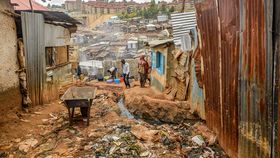


It is thought that there are roughly 2.7 billion people living on less than $2 a day, defined as moderate poverty by the World Bank. Trying to alleviate this is a major goal of the United Nations, and an aim that almost every nation agrees upon, yet it requires having detailed knowledge of which regions and communities are living in poverty, data that is surprisingly difficult to obtain. Now a study published in Science has found that by combining satellite imagery and artificial intelligence, they can accurately predict which regions are the most impoverished.
Traditionally the only method to obtain such data has been through household surveys, but this has major limitations. While it might work on a smaller scale, it is often difficult for poorer nations to scale it up, as the costs and logistics of surveying remote and sometimes dangerous regions on a frequent basis prevents research from being carried out. Because of these factors, between 2000 and 2010 it is thought that 39 out of the 59 African countries conducted fewer than two surveys rigorous enough to be able to calculate poverty levels.
In order to fill these gaps in the world data on poverty, researchers have turned to satellite data in the past, finding that nighttime images of light can be useful to a degree. In general, those areas that have heavy light pollution are useful in predicting the wealthier regions, but this is not refined enough at the opposite end of the scale. With an estimated 57 percent of African people, for example, living without electricity, it cannot tell the difference between those who are poor, and those living in poverty, generally defined as living on less than $2 a day.
To try and get around this problem, researchers from Stanford University decided to try and combine the nighttime images with other higher resolution images taken during the day. By identifying those regions using the night photos that seem to have the highest levels of poverty, and then using computer learning algorithm to pick out other features – such as paved roads, waterways, and tin roofs – they were able to single out and differentiate between the poorest of communities in five African countries (Uganda, Tanzania, Malawi, Nigeria, and Rwanda) to an incredibly accurate degree.
The ready availability of satellite images, which can be regularly updated, combined with the relatively cheap computer systems needed to assess the areas could transform how organizations track poverty. This could have knock-on effects on where governments and charities direct aid and resources to those communities most in need, and in the end, help lift millions of people worldwide out of severe poverty.