

On Friday, NASA released the first in a series of Pluto close-ups. These breathtaking views could be the best we ever see. The images were taken 15 minutes after closest approach from an altitude of 17,000 kilometers (10,000 miles) above the surface. The high-resolution photos feature details as small as half a city block.
The rest of this article is behind a paywall. Please sign in or subscribe to access the full content.“These new images give us a breathtaking, super-high resolution window into Pluto’s geology,” New Horizons Principal Investigator Alan Stern, of the Southwest Research Institute (SwRI) in Boulder, Colorado said in a NASA news release. “Nothing of this quality was available for Venus or Mars until decades after their first flybys; yet at Pluto we’re there already – down among the craters, mountains and icefields – less than five months after flyby! The science we can do with these images is simply unbelievable.”
Pluto’s northern hemisphere features a massive canyon system that spans hundreds of kilometers across. In the image seen above we see a section of this system that closely resembles the Badlands of South Dakota here on Earth. Over time, erosion and faulting have sculpted this section of Pluto’s icy crust into the rugged terrain we see today. The science team suspects that the central mountains are predominantly made of water ice, but have been altered by the flow of nitrogen and other exotic ices over time, leaving behind rounded peaks and short ridges. At the bottom of the 80 kilometer (50-mile) wide section featured in the image borders Sputnik Planum, the terrain drastically transitions into a fractured floor as we approach the icy plains.
NASA/JHUAPL/SwRI
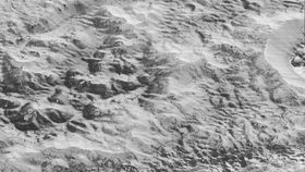
We see in this image what appears to be massive sections of Pluto’s water-ice crust jammed together in the informally named al-Idrisi mountains. The mountain sides differ in coloration with some appearing bright while others seems to be covered in a dark material. Several mountains appear to show crustal layering, that could be due to similar processes like we see with the layering in some of Pluto’s crater walls. Some of the mountains, towering as high as 2.4 kilometers (1.5 miles) above the surface, appear to have jostled around and trapped darker material between them. At the shoreline of Pluto’s icy plains — a region informally named Sputnik Planum after the first satellite in orbit — the mountains abruptly give way to smoother terrain composed of soft nitrogen ices. Forming a nearly level surface, the smooth surface of Sputnik Planum is disrupted only by the fine outlines of cell-like boundaries and a pitted, textured surface. Scientists think the pits form through sublimation.
"The mountains bordering Sputnik Planum are absolutely stunning at this resolution," said New Horizons science team member John Spencer of the Southwest Research Institute. "The new details revealed here, particularly the crumpled ridges in the rubbly material surrounding several of the mountains, reinforce our earlier impression that the mountains are huge ice blocks that have been jostled and tumbled and somehow transported to their present locations."
In this image, New Horizons provides new details of Pluto’s rugged craters. Most of the craters seen in this image are located within the 250 kilometer (155 mile) wide basin known as Burney Basin, after Venetia Burney who first proposed the name “Pluto” in 1930. Many of the craters in Burney Basin feature layered interior walls, which typically indicate to geologists that some sort of change in composition occurred. Right now, science team members cannot say if the layering seen here is local, regional, or global. According to the science team, “The darker crater in the lower center is apparently younger than the others, because dark material ejected from within – its “ejecta blanket” – has not been erased and can still be made out.” By studying the craters on Pluto’s surface, geologists will be able to learn a great deal about the planet’s history, including how it formed and how it evolved.
"Impact craters are nature's drill rigs, and the new, highest-resolution pictures of the bigger craters seem to show that Pluto's icy crust, at least in places, is distinctly layered,” said William McKinnon, deputy lead of the New Horizons Geology, Geophysics and Imaging team, from Washington University in St. Louis. "Looking into Pluto’s depths is looking back into geologic time, which will help us piece together Pluto's geological history.”
The movie is made from images captured by New Horizons’ Long Range Reconnaissance Imager (LORRI) of a section of Pluto’s surface spanning 80 kilometers (50 miles) wide. In contrast to previous images, these high-resolution images were lossless or uncompressed. Previous images were compressed so they could be beamed back at a faster rate. The latest images were also not obtained with the usual "point and shoot" mode. LORRI snapped pictures every three seconds while at the same time, the Ralph/Multispectral Visual Imaging Camera (MVIC) scanned the surface. As a result the images are six times better than the global map of Pluto, and five times better than the best images of Neptune’s largest moon Triton, captured in 1989 by Voyager 2.
“These close-up images, showing the diversity of terrain on Pluto, demonstrate the power of our robotic planetary explorers to return intriguing data to scientists back here on planet Earth,” said John Grunsfeld, former astronaut and associate administrator for NASA’s Science Mission Directorate. “New Horizons thrilled us during the July flyby with the first close images of Pluto, and as the spacecraft transmits the treasure trove of images in its onboard memory back to us, we continue to be amazed by what we see."
New Horizons is already more than 100 million kilometers beyond Pluto and has downloaded about 40 percent of the data it collected. The probe will finish sending it all back late next year, before turning it sights to its next target: 2014 MU69, a small icy world in the Kuiper Belt.