

In days gone by, being a spy was a tough job. It required unflappable nerve, a briefcase full of deadly contraptions, and a manageable drinking problem. Now, all you need is a smartphone.
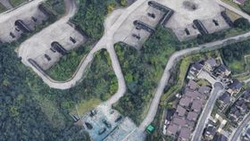
The rest of this article is behind a paywall. Please sign in or subscribe to access the full content.According to local media reports, an update of Google Maps shows detailed images of sensitive military facilities in Taiwan, including the National Security Bureau, the Military Intelligence Bureau, and a launch site for their US-made Patriot missiles. You can even make out the missiles from the maps.
The structures were revealed after Google released an extension of its original satellite mapping of four Taiwanese cities – Taipei, New Taipei, Taoyuan, and Taichung – that allows users to zoom into urban environments and see 3D renderings of buildings.
Taiwan is currently in the midst of longstanding geopolitical tension with China regarding the political status of Taiwan. In the simplest terms possible, China believes that Taiwan is part of their country, but many Taiwanese people want independence. The US is a close ally of Taiwan and regularly supplies the island with arms, including some reported to be visible in the images.
Taiwan’s Defense Minister Yen Teh-fa said that the news is not too much of a national security risk as they are not currently at war, but they will be closely working with the big boys in Silicone Valley to work out some appropriate adjustments. Speaking to The South China Morning Post, another defense official reaffirmed this, saying “the confidential parts are all inside the structures which would be highly difficult to expose through the 3D maps.”
Nevertheless, this is not the first time Google Maps has spiked the eyebrows of national security in Taiwan. Back in 2016, Taiwan asked Google to blur their images showing a suspected military installation on Itu Aba, a small island in the hotly disputed South China Sea, according to Reuters.
In a subtler vein, GPS data from a jogging app was used to highlight the location of military facilities, including the NSA and Area 51. Strava, the exercise app, released “heat maps” showing the running paths of their users across the world. Unfortunately, many members of military personnel forgot to turn off their data sharing and their paths traced the outline of military outposts. Doh!