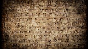
It was recently reported, to the delight of many, that a 4,000-year-old Assyrian baked clay tablet was likely a marriage contract. This, however, isn’t the only tablet of its kind – there are tens of thousands of others.
Now, as revealed in a new working paper, a careful translation of many of them has revealed something utterly remarkable: The locations of ancient metropolises that have been long lost to the sands of time.
Authored by Harvard University’s senior lecturer on Assyriology, Gojko Barjamovic, and an international team of economists, it has the potential to change how the Assyrian Empire is understood.
These tablets have all been excavated from the ancient city of Kanesh, located in modern-day Turkey. Written in the cuneiform script developed by the Sumerians of Mesopotamia, they are a mishmash of business transactions, accounts, seals, contracts, and so on – yes, even marriage certificates.
The tablets sound rather uninteresting to the layperson, but not to those with a trained eye. Business dealings always mention where they are taking place and perhaps where the trade is heading to or being received from. This means that the names and potentially the locations of cities that have yet to be found, those still buried beneath the Turkish soil, could be found within the texts.
After painstakingly going through 12,000 of these clay tablets, the team think that they’ve identified 26 of them; 15 have been found already, but 11 of them still elude capture.
The precise coordinates of the cities aren’t given though, but thanks to a now-defunct method of trading, the team think they know where most of them are regardless.

Kanesh, once a small trading settlement, became a major trading post for the entire region. The tablets are so detailed that the authors describe the city in their paper as a “flourishing market economy, based on free enterprise and private initiative, profit-seeking and risk-taking merchants, backed by elaborate financial contracts and a well-functioning judicial system.”
It’s this comprehensive record of accounts that revealed that Kanesh traded most with cities closer to it and less with those further away. Taking all this data and properly quantifying it, the team managed to essentially create a system of distance based on the frequency of trade between cities.
This system, which they call a “structural gravity model”, gives robust estimates as to where these lost cities might be. They note that for many of them, their approximations “come remarkably close to the qualitative conjectures produced by historians.”
Although they need to be found to confirm the accuracy of their system, this paper provides a remarkable tool for archaeologists. It’s a gateway to a kingdom that, for all intents and purposes, was the world’s first superpower.
[H/T: Washington Post]