


In July 2018, a shocking video started being shared across the Internet. Two women, accused of belonging to the terrorist group Boko Haram, are rounded up by soldiers and marched along with their young children to a spot where they are blindfolded, forced to the ground, and gunned down at close range.
The rest of this article is behind a paywall. Please sign in or subscribe to access the full content.Unfortunately, apart from a few nicknames and faces captured in the video, nobody knew when or where the footage was recorded, who the soldiers were, or even which country they served.
But two months later, thanks to some impressive detective work using not much more than Google Earth and Facebook, journalists at the BBC have finally figured out what happened – and they've explained how they did it in a fascinating viral Twitter thread.
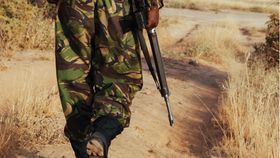
The first thing to do was to pin down where the atrocity took place. Although experts from Amnesty International quickly concluded that the footage showed Cameroonian soldiers, probably in the conflict-ridden Northern region of Cameroon called Mayo Tsanaga, the Cameroonian government rejected these claims as "fake news", citing the soldiers' uniforms and weapons shown in the video.
But the BBC journalists spotted an enormous clue hiding in the footage – the mountains in the background.
Using Google Earth, they found a match for the mountains' distinctive profile near a town called Zelevet, in the North of Cameroon near the border with Nigeria.
And once they knew the general area, they were able to use Google Earth to narrow it down even further. They used details such as roads, buildings, and trees to home in on the exact location of the killings.
Figuring out where the murders took place made it possible to work out when they happened as well. Comparing details in the footage to satellite imagery from between 2013 and 2018 showed that the video must have been filmed some time between 2015 and early 2016.
But some less obvious clues, along with a bit of mathematical know-how, allowed the journalists to narrow down the time of the murders to an astonishing degree. A glimpse of a dirt footpath in the footage told them that it must have been captured in Cameroon's hot, dry season – between January and April. And then, by using the soldiers in the video as makeshift human sundials, they were able to pinpoint the killings to just a two-week window.
The only question left was who the soldiers in the video were. Amnesty's investigators had already pointed out that their uniforms and insignias strongly suggested they were Cameroonian, but the BBC's journalists actually managed to identify one of the individuals in the video – and they did it using one of the best, most detailed databases on the planet: Facebook.
Thanks to their Facebook-surfing, they were also able to debunk the "fake news" claims. For instance, although the government said soldiers in that area would not wear the "forest" uniforms shown in the footage, the BBC found photos showing just that: Cameroonian soldiers in uniforms matching those in the video, and tagged to the exact location determined by the journalists.
In August, a month after the video originally surfaced online, Cameroon's Minister of Communication released a statement saying that seven members of the military had been disarmed, arrested, and imprisoned while under investigation. Three of the soldiers on the list could be matched to the footage thanks to the work by the BBC.