


When it comes to the Incan city of Machu Picchu, it appears that a geological “X” marks the spot.
The rest of this article is behind a paywall. Please sign in or subscribe to access the full content.More than 500 years ago, ancient Incans intentionally built Machu Picchu and a number of other cities in places where tectonic faults meet, according to findings presented on September 23 at the annual Geological Society of America meeting in Arizona.
"Machu Pichu's location is not a coincidence," said researcher Rualdo Menegat, a geologist at Brazil’s Federal University of Rio Grande do Sul, in a statement. "It would be impossible to build such a site in the high mountains if the substrate was not fractured."
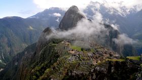
Seemingly carved into Peru’s remote Andean mountain range, Machu Picchu sits atop a narrow ridge more than 2,400 meters (7,800 feet) above sea level. Around 200 individual structures made this urban center one of the largest of the Incan Empire with a population of 1,000 people at its peak, according to UNESCO. Since its unveiling to the world in 1911, the rainforest city has presented as many questions as it has answers.

In particular, researchers have wondered why such elaborate buildings would have been built in such an inaccessible location. The answer may lie below ground. A combination of satellite imagery and field measurements paired with a geoarchaeological analysis suggests that the city is built above the intersect of a web of fractures and fault lines of varying lengths and sizes.
“We show that the Inca developers intentionally chose cross-tectonic faults to build their cities. Indeed, in Machu Picchu, the rocks were so fragmented that it was possible to build cities in high topographic levels, strategically safe against both geological hazards and inhospitable Andean conditions. In addition, the main sectors, buildings, and stairs were built following the three said fault directions,” reads the study abstract.
Machu Picchu is perhaps most well-known for its intricately built structures. Mortar-free masonry stones are fitted together in such a way that it is impossible to slide even a credit card between them, which could have saved the city from destruction several times over. Peru is a seismically active region and when earthquakes occur, it has been noted that the meticulously placed stones “dance” and fall into their intricately designed places – a feat that has kept the buildings from collapsing for hundreds of years, according to National Geographic. The new analysis “clearly shows” the empirical fault and fracture map that underlies the construction of Machu Picchu in several sets, some of which correspond to the very fault zones that uplifted the Central Andes Mountains over the last 8 million years.
“The intense fracturing there predisposed the rocks to breaking along these same planes of weakness, which greatly reduced the energy needed to carve them,” said Menegat.
There would have been other advantages to building a city over a tectonically active area. Faults that channel meltwater and rainwater to the city would have helped drain the site following intense rainstorms common in the region. As many as two-thirds of building efforts were dedicated to subsurface drainages in what has been called a “significant public works achievement," according to previous research. Additionally, the city’s high placement would have isolated it from avalanches and landslides.
However, it is unclear whether the Incans knew their prime real estate was located at the intersect of two fault lines or if the seismic activity that comes with it made the location ideal for setting up shop.
