


Northerners are brash, unsophisticated Frank Gallagher-types. Southerners are arrogant snobs along the lines of Blackadder or Edina and Patsy from Absolutely Fabulous. Of course, these stereotypes are (on the whole) wildly off the mark but that hasn't stopped us Brits from debating who has it best – the North or the South – and the correct pronunciation of the word "bath" since time immemorial.
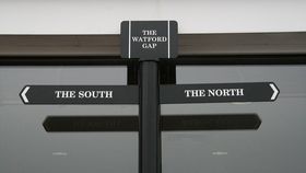
The rest of this article is behind a paywall. Please sign in or subscribe to access the full content.There are disagreements on where the North ends and the South begins but the Watford Gap is the official dividing line. It stands somewhere close to Watford village in Northamptonshire, England. Researchers now believe this division could hark all the way back to Viking times.
Archaeologist Max Adams noticed a distinct lack of Scandinavian placenames southwest of Watling Street when he was researching for his new book. Watling Street is an old Roman road that served as a connection between Londinium (what is now London) and Viroconium (now Wroxeter), Roman Britain's fourth largest city. This road is now called the A5.
There are perhaps a handful of Viking placenames, if any, below this point. But travel north of this road and you'll come across hundreds of villages and towns with names like "Fishguard", "Grimethorpe", and "Haverigg".
"Clearly, the Scandinavian settlers stopped at Watling Street," Adams told The Guardian.

After further investigation, Adams observed that to the north-east of Watling Street rivers flow into the Irish Sea or the North Sea, whereas to the south and west they flow into the River Severn or the Thames. As he points out, we don't need to pay attention to the direction of river water flow today because we can build a bridge to cross from one bank to another. In Viking times, however, people would have paid attention.
"Your natural trading routes are along rivers and all the medieval monastic estates used the rivers as their arteries of power. So clearly the geography of power has always mattered," Adams explained.
"This is England’s natural fault line, its continental divide: the watershed that divided and divides north from south (epitomised by the famous Watford Gap, on the A5/M1 north-east of Daventry); and I have no doubt that Scandinavian armies and settlers knew its imperatives.”
After years of conflict between the Danes and the Anglo-Saxons, Guthrum, a Viking leader, brokered a peace treaty with King Alfred, King of Wessex, in 886AD. Watling Street became the diving line between the two kingdoms. This border was strengthened in the early 10th century when Abert's son and successor, Eadweard the Elder, took the throne.
“I’m not sure whether people on the north side of Watling Street immediately feel themselves different or whether that’s more of a southern joke. But clearly it’s a joke with a very old reality attached to it," Adams said.