


A Reddit user taught the internet a little bit about geography this week, as they discovered what looked like a black hole slap bang in the middle of the ocean. Having stumbled across the topographical oddity while on a rather deep dive into Google Earth, a user named kokoblocks posted a screengrab on the subreddit /r/GoogleMaps taken from the middle of the Pacific Ocean with the caption “what the F*CK this looks nothing like an island”.
The rest of this article is behind a paywall. Please sign in or subscribe to access the full content.So, what is it?
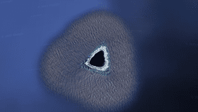
Known as Vostok Island, the confusing spit of coral is an atoll in the Southern Line Islands, Kiribati, in the Pacific Ocean. The uninhabited island sits 640 kilometers (400 miles) from Tahiti and is home to just 0.3 square kilometers (0.1 square miles) of land. It was discovered in 1820 by Fabian Gottlieb von Bellingshausen, a Russian Antarctic explorer sailing on a ship named Vostok. Coveted for its guano (then-lucrative poop deposits), it was nabbed by the US under the 1856 Guano Act and later by Britain in 1873, though nobody ever ended up using it for anything.
Having been declared a wildlife sanctuary in 1979, it’s now home to untouched indigenous flora, the best of all the Line Islands, as a part of Kiribati. This may explain why the island appears so strange on Google Earth, as if you zoom in on the island it almost looks as if it has been censored with its outskirts appearing dark green while the main body looks black. Satellite imagery sites do sometimes block certain images in this way, though it’s also possible that the unusual effect is simply a low-resolution image of a dense forest.
This latter explanation ties in nicely with the makeup of the land, with beaches made up of coral sand and rubble and no fresh water deposits on the mainland. The island is largely covered with Pisonia trees which grow to heights of 30 meters (98 feet) so tightly packed together that there’s no space for other plants beneath them. The island's complexion could therefore reflect a rather uniform mat of Pisonia treetops.
Far from a “black hole”, as some on Reddit described it, the unusual spit of land is home to a surprising variety of fauna including several species of booby and frigate birds, terns, rats, skinks, and coconut crabs, with green turtles occasionally visiting its beaches.
So, not that unusual really – but there were some great alternative explanations on Reddit.