


The tragic fate of flight MH370 is unlikely to ever be solved, as the passenger jet flying between Kuala Lumpur and Beijing went missing on March 8, 2014, less than an hour after take-off. An international search across vast tracks of ocean failed to turn anything up. But it has revealed some of the mysteries of the deep.
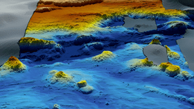
The rest of this article is behind a paywall. Please sign in or subscribe to access the full content.As organizations and governments scanned the waters of the Indian Ocean for the plane, they turned what was once a remote region of the planet into one of the world’s most meticulously mapped parts of the deep sea. In the process, they have produced some stunning images.
Australian government agency Geoscience Australia was coordinating the intense search and have now released some of their data and maps created during the year’s long operation. The results are an astonishing glimpse into a little studied region, showing twisting canyons, rocky outcrops, and expansive plateaus.

“It is estimated that only 10 to 15 percent of the world's oceans have been surveyed with the kind of technology used in the search for MH370, making this remote part of the Indian Ocean among the most thoroughly-mapped regions of the deep ocean on the planet,” explains Dr Stuart Minchin, chief of Geoscience Australia's Environmental Geoscience Division, in a statement. “So this data is unique both because of the remote location of the search area, and because of the sheer scale of the area surveyed.”

The data is so detailed, in fact, that they are even able to document other objects that litter the sea bed, showing a whole host of shipwrecks, some of which are intact and some of which are broken apart. The images are in such a high resolution that they are even able to identify much smaller objects that are but a pinprick on the ocean's floor, including ship cables, individual oil barrels, and whale skeletons.
The government hopes that while the search was unable to locate the flight, the data obtained can be put to use by geologists, marine biologists, and other scientists alike. While they have only released a portion of the data so far, the plan is to publish a second set at some point in 2018.