

Archeologists are looking deep into the past of Britain's lost coastal history using laser technology. With the help of a revolutionary technique called LiDAR, archeologists have revealed traces of previous human activity on Ramsey Island in Wales, including ancient burial mounds, a prehistoric fort, and a structure that appears to be a lost religious chapel.
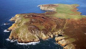
The rest of this article is behind a paywall. Please sign in or subscribe to access the full content.It’s known that Ramsey Island, a 1-kilometer (0.62-mile) strip of ragged rock off the western tip of Wales, has been a hive of human activity for centuries, but much of this past has remained a mystery. To dig deep into the island's history, without actually doing any digging, researchers from the CHERISH project have recently taken a helicopter to the island to survey it using LiDAR technology.
LiDAR technology was first developed in the early 1970s to map the surface of the Moon for the Apollo 15 missions, but it’s since proved extremely useful at surveying Earth for archaeological or geographical purposes. In short, the technique beams a laser at a target and analyzes the light that is reflected back. This allows researchers to view beyond the layers of trees or vegetation that would otherwise obscure features from the distant past.

In the north of Ramsey Island, the technology has revealed lengthy stretches of ancient plow ridges – a sure sign of agriculture. The ridges were also found around the site of a coastal fort, suggesting that the fortification was perhaps a permanently defended settlement.
The south features the remains of several pillow mounds, a hint that the area was likely used for animal husbandry, perhaps once home to rabbits during the medieval and post-medieval period.
One of the most captivating finds was the site of a possible lost chapel on the east of the island. The researchers believe the shape strongly suggests it was once a religious complex as it appears to have had ponds, platforms, and enclosures, as well as a clear view across the waters towards the city of St Davids.
“We have added a wealth of new archaeological sites to the story of Ramsey Island, using an incredible 3D dataset which has presented us with a stunning view of the island in enormous detail,” Dan Hunt, CHERISH archaeologist at the Royal Commission, said in a statement. “We look forward to working closely with the wardens of RSPB Ramsey Island, and other colleagues in Pembrokeshire Coast National Park, to investigate these discoveries further.”