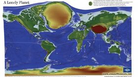


If you really feel like escaping from the world, and that quiet spot you used to run away to as a kid just won’t cut it, then you might want to use this map as a guide.
This cartogram-- world maps in which territories are resized according to a particular variable-- was created by geographer Benjamin Hennig, the creator of the website Views Of The World which has tons more awesome data visualizations like this one.
The idea behind this particular map was to visualize the loneliest places on Earth, but rather than showing us the most and least populated areas, the cartogram highlights the remotest areas. To do this, the travel time that is necessary to reach the nearest major city (defined as having over 50,000 inhabitants) from a given point was calculated, and then each grid cell was resized accordingly. The most remote places therefore appear as the biggest areas on the map, such as Greenland, while the more densely settles areas almost disappear, such as India.
From Hennig’s website: “It draws an image of the areas that are almost disconnected from those shrinking effects of globalization. This world map is the striking opposite representation of our image of a globalized and interconnected world, of those vanishing places that we thought do not exist anymore.”
[Via Views Of The World and PopSci]